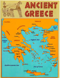
On the Ancient Greek Maps of the world, Greece is a country in southeastern Europe and its peninsula extends from the Balkans into the Mediterranean Sea.Greece is relatively a young country that was created after the war of Independence in 1821.
The independent state of Greece was established in 1832 with the Constantinople treaty. It is mountainous, with many gulfs and bays. Forests fill some areas of Greece. Much of Greece is stony and suitable only for pasturage, but other areas are suitable for growing wheat, barley, citrus, dates, and olives.
It is convenient to divide ancient Greece into 3 geographical regions:
1. northern Greece,
2. central Greece and
3. the Peloponnese
According to the Ancient Greek maps, from the north, Greece borders with Albania FYROM and Bulgaria. Northern Greece consists of Epirus and Thessaly, separated by the Pindus mountain range. The chief town in Epirus is Dodona where the Greeks thought Zeus provided oracles. Thessaly is the largest plains area in Greece. It is almost surrounded by mountains.
On the north, the Cambunian range has as its highest mountain the home of the gods, Mt. Olympus, and nearby, Mt Ossa. Between these two mountains is a valley called the Vale of Tempe through which runs the Peneius River.
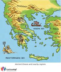
In the east, it borders with the European part of Turkey. To the west of Greece is the Ionian Sea and to the east is the Aegean Sea. Central Greece has more mountains than northern Greece.
It contains the countries of Aetolia (famed for the Calydonian boar hunt), Locris (divided into 2 sections by Doris and Phocis), Acarnania (west of Aetolia, bordered by the Achelous River, and north of the Gulf of Calydon), Doris, Phocis, Boeotia, Attica, and Megaris.
Boeotia and Attica are separated by Mt. Cithaeron. In northeast Attica is Mt. Pentelicus home of the famous marble. South of Pentelicus is the Hymettus mountain range, which is famous for its honey.
Attica had a poor soil, but a long coastline favoring trade. Megaris lies in the Isthmus of Corinth, which separates central Greece from the Peloponnese. The Megarians raised sheep and made woolen products and pottery.To the south is the Libyan Sea.
Ancient Greek Maps
South of the Isthmus of Corinth is the Peloponnese (21,549 sq. km), whose central region is Arcadia, which is a plateau over mountain ranges. On the northern slope is Achaea, with Elis and Corinth on either side.
On the east of the Peloponnese is the mountainous Argolis area. Laconia was the country in the basin of the Eurotas River, which ran between the Taygetus and Parnon mountain regions. Messenia lies to the west of Mt. Taygetus, the highest point in the Peloponnese.
The coastline of Greece is 13,676 km. Most of the Greek islands and islets are situated in the Aegean sea, while a small number of islands are in the Ionian Sea. The mountains divide the territory into several compartments which are difficult to communicate between them. The mountainous terrain prevents communication and exchange of goods.