The word Greece had come from the Roman name for a Country which was called, ‘Graecia’ and the Greeks called their land, ‘Hellas’.
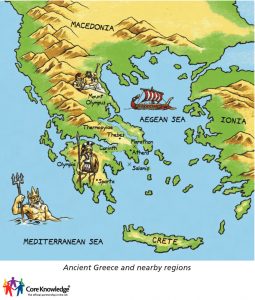
Greece basically is made up of a huge mainland which is at the southern tip of the Balkans, the peninsula of Peloponnesus and also several islands which include Rhodes, Crete, Euboea, Dodecanese, Kos and also the Ionian sea islands. This country has around 15,000 kilometres of coastline and also a huge boundary which is around 1,160 kilometres.
An important aspect of ancient Greek geography was farmland since farming was very important at that time. The Greeks would have their own private space which would consist of land for farming. Sometimes the farmland would also be divided among the owners.
Major physical features
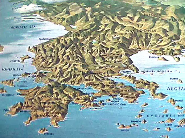
- Mountains: In ancient Greek geography, around 80 per cent of the country consisted of hills or mountains and hence this made Greece one of the mountainous countries of entire Europe. If you go to western Greece you will find that it is filled with wetlands and also lakes. The central mountain range which is the Pindus has a maximum elevation of around 2,600m. it is also considered the prolongation of the Dinaric Alps. The range continues with the Peloponnese along with the islands of Antikythera and Kythera and finally to the island of Crete.
- The Aegean sea: The Agean is a huge part of ancient Greek geography which has shaped its culture and practices. The easy access to the sea made overseas trade more easier and advantageous than communication with other Greek states. It made them prosperous and also was a reason for the spread of Greek culture worldwide.
- Islands: Greece can be said to be a set of islands rather than a concrete landmass. It consists of about 1000 islands scattered around the Aegean and the Mediterranean. These islands were another reason for such isolated growth of states in the region. The main islands housing the larger states were Crete which was the biggest of them and Rhodes, Chios, and Delos.
Physical Regions in Ancient Greece
- Central Greece
- Northern Greece
- Peloponnese
- Islands
Central Greece
The central, as well as western ancient Greek geography, is considered to be a sea of high steep peaks which are broken down by canyons and other landscapes which include the Meteora and also the Vikos gorge. It is located to the north of Peloponnese covering an area of about 24,000 km,
This, later on, became the second largest gorge on earth following the Grand Canyon. The highest point in ancient Greek geography was Olympus which was around 2,919 meters above sea level.
Apart from hills and mountains it also consisted of a large number of lakes and rivers with the second largest river of Greece, Acheloos flowing through the region.
Northern Greece
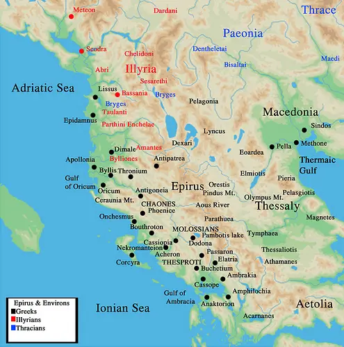
Northern Greece was also represented by the Rhodope which was located in the eastern part of Macedonia as well as Thrace. The area was covered with thick and vast forests like the famous Dadia.
The plans would mostly be found in the Eastern part of Thessaly, Thrace and also Central Macedonia. Around 80 per cent of the ancient Greek land was covered by vegetation which varies from place to place. The variety includes everything ranging from coniferous to Mediterranean type.
Peloponnese
The Peloponnese is the southern part of Greece and the largest peninsula in Greece surrounded by the Ionian sea, Aegean sea, the Mediterranean sea and the Corinthian gulf. It is connected to the Greek mainland only through a narrow strip of land known as the isthmus of Corinth.
Islands
There are a lot of small islands scattered around the Greek mainland which were also a big part of the ancient Greek world. There are certain groupings of islands like the Cyclades islands, the Dodecanese, and the Northern Aegean islands. These islands became a great part of political games in the ancient Greek world and were a big reason for the Peloponnesian war.
Flora and Fauna
In the seas, around ancient Greek geography, one could find turtles, seals, and various other marine life. Greece’s forests would also provide a home to different brown bears as well as lynx. it would also host wolves, roe deer, foxes, wild boars, wild goats and other animals as well.
How did ancient Greece’s geography affect its development?
Ancient Greek lands were covered with mountains and it accounted for at least 80 per cent of its lands making the connection between Greek cities very difficult. The roads were also very difficult and the best way for communication was through the seas which made overseas communication easier. This aspect of geography led to the development of Greek states quite isolated into city-states with their various political structures, economy and culture.
Another effect of such mountainous land was the difficulty in agriculture with only 20 per cent of land fit for growing crops. The Greek farmers also grew olives which could be easily grown on mountain slopes. Cereals were hard to grow in ancient Greece which often led to scarcity.
The scarcity in food was again the reason for their frequent warfare for capturing lands which would generate surplus wealth for their economy and so states like Athens based their prosperity on their colonies supplying them with great wealth and tributes.
The easy access to seas also made trade easy for Greek states which led to a very prosperous overseas trade and was a huge reason for its great riches and spread of Greek culture worldwide.
Ancient Greece vs modern Greece geography
A huge number of years differentiate ancient Greece from modern Greece, making it obvious there have been certain changes in its geography over such a long time.
Firstly, the ancient Greek land we study about includes lands in Asia that form parts of modern-day Turkey and even parts of Italy like the island were included in Ancient Greece.
Another thing we should keep in mind is that ancient Greece was not a single state or kingdom like the modern state in Europe. It consisted of about 1000 city-states with different cultures, political structures and economies, the only common thing being 1000 city-states with their different culture, political structure and economy with the only common thing being its language.
But of course, even with such a long interval of time in between the fundamental aspects are still the same. It still resides on the southeastern tip of Europe around the Aegean sea with Persia or Turkey to its east and Africa to its south.
Ancient Athens geography
Athens was situated in central Greece and a zone known as Attica. They had very close proximity to the sea which led them to develop the strongest navy and prosperous sea trade.
They had an urban way of life and being close to the sea, storms were common which made agriculture erratic which had forced them to look more closely at the overseas grain trade.
Ancient Sparta geography
Sparta was placed in the Peloponnesian region having mostly mountainous terrain and no outlet to the sea. It was supplied with fresh waters from the Eurotas River and it also provided them protection to the east along with Mt. Taygetus to the west. Sparta was also covered to the north by the hills in northern Laconia. It made it almost a natural fortress and made them secure from invasions.
This terrain also made them harder as prosperity was hard to come by with so few natural resources and thus lived a frugal life despising luxuries.
Their main source of income was the agricultural wealth from Messenia, which was one of the most fertile lands in ancient Greece.